


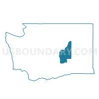
Gloyd Voting District, Grant County, Washington
About
Outline

Summary
| Unique Area Identifier | 684334 |
| Name | Gloyd Voting District |
| County | Grant County |
| State | Washington |
| Area (square miles) | 76.86 |
| Land Area (square miles) | 76.29 |
| Water Area (square miles) | 0.57 |
| % of Land Area | 99.26 |
| % of Water Area | 0.74 |
| Latitude of the Internal Point | 47.30497940 |
| Longtitude of the Internal Point | -119.24324720 |
Maps


Graphs
Select a template below for downloading or customizing gragh for Gloyd Voting District, Grant County, Washington


Neighbors
Neighoring Voting District (by Name) Neighboring Voting District on the Map
- Airport 2 Voting District, Grant County, WA
- Lakeview Park Voting District, Grant County, WA
- Longview Voting District, Grant County, WA
- McConihe 2 Voting District, Grant County, WA
- Ruff Voting District, Grant County, WA
- Stratford Voting District, Grant County, WA
- Wheeler Voting District, Grant County, WA
- Wilson Creek Rural Voting District, Grant County, WA
Top 10 Neighboring County Subdivision (by Population) Neighboring County Subdivision on the Map
- Moses Lake CCD, Grant County, WA (34,043)
- Gloyd CCD, Grant County, WA (1,997)
- Wilson Creek CCD, Grant County, WA (968)
Top 10 Neighboring Place (by Population) Neighboring Place on the Map
Top 10 Neighboring Unified School District (by Population) Neighboring Unified School District on the Map
- Moses Lake School District, WA (39,664)
- Ephrata School District, WA (11,632)
- Wilson Creek School District, WA (583)